Estimated reading time: 7 minutes
DJI Zenmuse L2: LiDAR & 3D Data Acquisition Explained
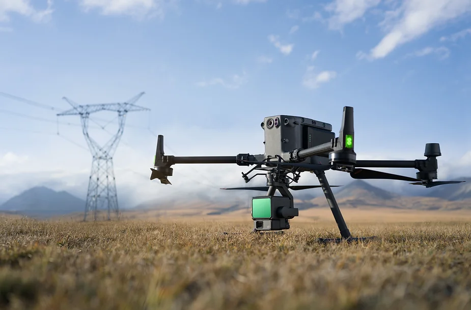
The Zenmuse L2, a dual surveying payload created for LiDAR and photogrammetry applications was just launched by DJI. The L2 offers greater effectiveness, precision, and data quality than its predecessor, the Zenmuse L1. Below are the features of the Zenmuse L2 and how they can enhance drone surveying.
Table of contents
Zenmuse L2 Product Overview:
1. End-to-end Solution:
The Zenmuse L2 is a significant advancement in attaining more accurate, efficient, and dependable 3D data collecting. It is designed for professionals utilizing DJI Matrice 300 RTK or DJI Matrice 350 RTK drones. It becomes a whole solution for high-precision 3D data collection and processing when combined with DJI Terra.
2. Application Fields:
It uses aviation LiDAR technology and offers exceptional hardware performance making it possible for experts in a variety of fields to quickly acquire large-scale 3D data, including surveying, mapping, power line inspection, forestry, and infrastructure management. The Zenmuse L2 greatly decreases fieldwork time when compared to conventional manual measurement techniques, increasing operational effectiveness.
3. Highly Integrated:
The system can detect objects up to 250 meters at low reflectivity and up to 450 meters under optimal conditions, offering a significant improvement in detection range. With a typical operating altitude of 120 meters, it delivers high-precision 3D point cloud data suitable for detailed ground surveys, achieving centimeter-level accuracy in both elevation and positioning.
4. Product Positioning:
The upgraded freestanding inertial measurement unit (IMU) on the Payload ensures rapid readiness and an enhanced field experience. The Zenmuse L2 can rely on incredibly exact data on drone placement, speed, and attitude by utilizing the drone’s RTK positioning technology.
How to Use a LiDAR Drone for 3D Mapping and Surveying
How to Use a LiDAR Drone for 3D Mapping and Surveying
- Define the Survey Area and Objectives
Clearly identify the survey area and determine the purpose of the mission, such as terrain modeling or infrastructure analysis, as this directly impacts flight settings and data requirements.
- Prepare the Drone and LiDAR Payload
Securely mount the LiDAR payload on the drone and ensure compatibility with the platform. Check battery levels, sensors, and calibration to guarantee safe and accurate operation.
- Configure Flight Parameters
Set appropriate flight altitude, speed, and overlap based on the required data accuracy. Proper configuration ensures consistent coverage and reduces the need for re-flights.
- Execute the Automated Flight Mission
Use flight planning software to carry out the mission automatically. This minimizes human error and ensures efficient and complete data collection.
- Process and Analyze LiDAR Data
After the flight, process the collected data using specialized software to generate accurate point clouds and 3D models for analysis and decision-making.
The Zenmuse L2’s RGB mapping sensor camera features a 4/3-inch CMOS sensor with a mechanical shutter and 3.3-mm pixels, resulting in high-precision photos that enhance the intricacies of colored point clouds and boost the number of maximum effective pixels to 20MP. Further lowering operational expenses, the minimum photo interval has been lowered to 0.7 seconds, and the mapping camera shutter can take up to 200,000 photos.
Two Scanning Modules:
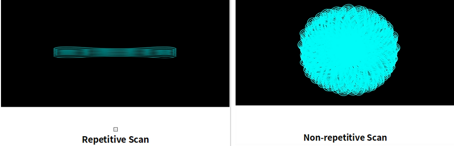
The Zenmuse L2 offers two scanning modes: repetitive, which enables the L2’s LiDAR to obtain more uniform and precise point clouds, meeting the needs of high-precision mapping; and non-repetitive, which offers deeper penetration for greater structural information, making it appropriate for power line inspections, forestry surveys, and other scenarios.
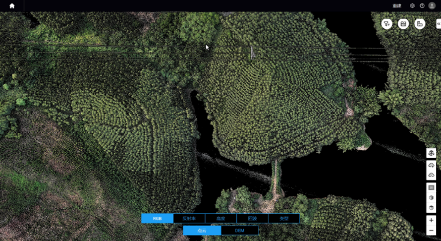
DJI Pilot 2:
Three display modes are supported by the operating software, DJI Pilot 2: RGB, point cloud, and side-by-side point cloud/RGB, which allows for easy result interpretation. The Zenmuse L2 can automatically produce mission quality reports using DJI Pilot 2.
Product Comparison:
| Function | L2 | L1 | Comparative analysis |
|---|---|---|---|
| Efficiency comparison | The operating area of a single mission can reach 2.5 km2 (The relative altitude of the mission is 150 m and the flight speed is 15 m/s) | The operating area of a single mission can reach 2 km2 (The relative altitude of the mission is 100 m and the flight speed is 13 m/s) |
Under the same accuracy conditions (1:500 resolution): 1. L2: The typical operating height is 150 meters, and the area of a single sortie can reach 2.5 square kilometers. 2. L1: 50 meters operating height, single sortie area is 0.5 square kilometers; 3. Single mission efficiency increased by 5 times! |
| Returns | Support 5 returns | Support 3 returns | Compared with L1, L2’s penetration is greatly improved |
| Point cloud data rate |
Single return: Maximum 240,000 points/second Multiple return: Maximum 1,200,000 points/second |
Single return: Maximum 240,000 points/second Multiple return: Maximum 480,000 points/second |
|
| Spot size | L2 laser spot size is 4 × 12 cm @ 100 meters, only 1/5 of L1 | ||
| Point cloud penetration | Under the same environment and flight parameters, the ground point density of L2 is more than 3 times that of L1. | ||
| Results accuracy |
Vertical accuracy 4 cm Horizontal accuracy 5 cm (The relative altitude of the mission is 150 m and the flight speed is 15 m/s) |
Vertical accuracy 5 cm Horizontal accuracy 10 cm (The relative altitude of the mission is 50 m and the flight speed is 10 m/s) |
Under the same mission height of 150 m: 1. L2 accuracy is satisfied, elevation 4 cm, plane 5 cm; 2. L1 accuracy > 20cm 3. The accuracy of the results is improved by 4 times! |
| Point cloud thickness | Under the same environment and flight parameters, the thickness of L2 point cloud is 1/3 of L1 | ||
| Measure distance |
250 meters (reflectivity 10%, 100 klx) 450 meters (reflectivity 50%, 0 klx) |
190 meters (reflectivity 10%, 100 klx) 450 meters (reflectivity 80%, 0 klx) |
1. Compared with L1, the measuring range of L2 is increased by 30%; 2. The typical operating altitude can reach 150m, the detection range is longer, and the flight is safer. |
| Laser Ranging | Supported, up to 450m | Not supported | |
| FOV |
Repetitive scan: 70°×3°; Non-repetitive scan: 70°×75° |
Repetitive scan: 70.4°×4.5°; Non-repetitive scan: 70.4°×77.2° |
|
| IMU warm-up | No need to warm up before takeoff | Warm up for 5-10 minutes before takeoff |
1. Inertial navigation does not require preheating, which increases the effective time of the operation; 2. The accuracy of inertial navigation has been improved, the manual route inertial navigation calibration interval has been increased by 67%, and the effective operation time has been increased. |
| Inertial navigation calibration |
Manual route: 200s; Automatic route: 100s |
Manual route: 120s; Automatic route: 100s |
|
| Yaw accuracy | Real-time 0.2°, post-processing 0.05° | Real-time 0.3°, post-processing 0.15° | |
| Pitch and roll accuracy | Real-time 0.05°, post-processing 0.025° | Real-time 0.05°, post-processing 0.025° | |
| Visible light camera sensor size | 4/3 inches | 1 inch |
1. The life of the mechanical shutter is increased by 4 times; 2. The shortest photo interval supports 0.7 seconds, and only performing orthophoto operations can greatly improve efficiency; 3. Point cloud real-time preview has a better look and feel. |
| Visible light camera effective pixels | 20M | 20M | |
| Mechanical shutter life | 200,000 times | 50,000 times | |
| Visible light camera photo interval | 0.7 seconds minimum | 2 seconds minimum | |
| Various route types | support | support | |
| Point cloud real-time preview | Support, point cloud rendering optimization | support | |
Summing Up
The DJI Zenmuse L2 represents a significant advancement in LiDAR-based drone surveying, delivering high-precision data, improved efficiency, and reliable performance for professional mapping applications.
Frequently Asked Questions About LiDAR Drone Surveying
LiDAR (Light Detection and Ranging) uses laser pulses to measure distances between the sensor and the ground, generating highly accurate 3D point cloud data for mapping and analysis.
It provides improved accuracy, longer detection range, and more efficient data acquisition, making it suitable for high-precision surveying projects.
It is compatible with professional RTK-enabled platforms such as DJI Matrice 300 RTK and DJI Matrice 350 RTK, ensuring stable flight and accurate positioning.
Industries such as surveying, construction, forestry, infrastructure inspection, and energy benefit from accurate and efficient data collection.
LiDAR is more effective for capturing accurate elevation data and penetrating vegetation, while photogrammetry is better for visual detail and cost-efficient projects.
Interested in next‑generation LiDAR and 3D data acquisition?
Contact NineTenths today to explore how advanced solutions like the DJI Zenmuse L2 can elevate your surveying, mapping, and 3D modeling workflows with high‑precision aerial data